Dark Entry Ravine


it's dark here


The Dark Entry Trail was a separate hiking trail way back in time. 1930's..1920's...? It by reference was a 'blue blazed hiking trail' in the 1930's prior to when the Appalachian Trail even existed. In modern times it was part of the Appalachian Trail (More confusion here. The Appalachian Trail did follow Bonney Brook down to US Rt 7 leaving Dark Entry Road. This change a couple decades ago ? Dark Entry Road is simply an ancient abandoned 'wood road' except the first section down by Cornwall Bridge. By memory it was passable perhaps by a 4 wheel drive vehicle into the 1960's but as of late 1900's NO. It junctioned with Dudleytown Road. Another interesting thing is there is no evidence these old TOWN ROADS were ever surrendered by the Town of Cornwall as the Dark Entry Forest Association would pretend.


click for larger image click for larger image


A decade or so ago when the Appalachian Trail was re-routed and the old trail (possibly not 'exact' route) is now known as the Mohawk Trail.

Follow this ? In brief the Dark Entry Trail existed prior to any Appalachian Trail. Its exact route is unknown except it is presumed to have followed the old wood road -- Dark Entry Road --

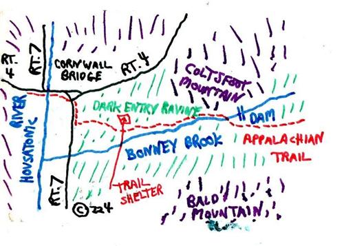
The Appalachian Trail was routed via this area in late 1900's. Its route changed one time to follow Dark Entry Road out of Cornwall Bridge vs. going down along Bonney Brook to US RT. 7. TODAY all is gone except the Mohawk Trail..a blue blazed trail...follows the old Appalachian Trail route. The Mohawk Trail has to be referenced elsewhere as that has been re-routed of recent eras to 'get off Dark Entry Forest Association property'.


click for larger image click for larger image click for larger image click for larger image click for larger image click for larger image


  1. Old Trail area maps
  2. Old Trail area maps
  3. Old Camping Zone 10 Shelter-Dudleytown Area. Me and my brother and sister staying overnight in the 1960's. I think this was about the end for this shelter.
  4. Old Trail area maps
  5. 1930 era map. Dark Entry Trail existed then !!
  6. Old Trail area maps


-- from 'Short Walks of Connecticut' -- by Eugene Keyarts -- The Pequot Press,Inc. -- Stonington,Ct. -- 1968


Man has always been apprehensive of the unknown, the left, the dark. We too often attach connotations of evil to ominous sounding words which are quite innocent. Do not allow the threatening sound 'dark entry' frighten you away from this enlightening exploration.

There is no portending evil in the title of this short walk. Dark Entry Ravine is quite the contrary of its inauspicious name. It is a pleasant and delightful natural feature that emits an atmosphere of blithesome well-being.

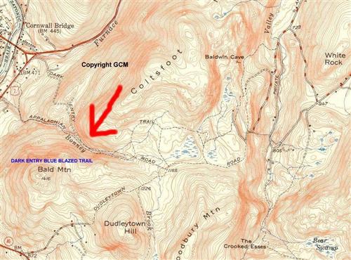
Dark Entry Ravine is on the Appalachian Trail [[ the Appalachian Trail no longer travels this route. In its place a blue blazed trail in 2003 called the Mohawk Trail but this trail has been open-closed at unknown times by the 'Dark Entry Forest Association' which lays claims to the land and area is supposedly being surveyed. The last resident of the area founded this Association..a Dr.Clark...(who's wife went insane) and claims to about 900 acres of land. ]] in the town of Cornwall, Litchfield County. The ravine is the course of Bonney Brook as it cascades toward the west between Coltsfoot Mountain to the north and Bald Mountain on the south.

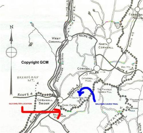
The beginning of the trail leading to Dark Entry Ravine is reached by following road map routes to the juncture of Rt's.4 and U.S.7, at Cornwall Bridge. From this junction follow Rt.U.S.7 south 500 feet to the Appalachian Trail crossing. The trail is marked on the east shoulder of the highway by a blue oval sign lettered in white with the trail name.The trail is also indicated by painted white-blazes on trees and rocks.

Leave car parked well off the traveled portion of the highway. Take trail toward the east entering mature woods and ascending lower contours of Coltsfoot Mountain, then descending into Dark Entry Ravine. The blazed trail follows Bonney Brook upstream through a heavily forested notch with attractive waterfalls and pools.

Along this section of trail is to be found a typical Appalachian Trail lean-to shelter with fireplace. On the shelter is a sign, placed there by members of the Appalachian Mountain Club, with this warning in part--"This trail and area is patrolled at regular intervals....Anyone guilty of destroying or defacing property or cutting down living trees..will be prosecuted...."

What a sad commentary on human nature it is that a sign of this type is necessary to warn up against destroying and befouling those things which gave us pleasure and sustenance. Are we instinctively urged by our preying past to still consider all things as booty to be plundered? The reason for this sign is the only dark spot in all of Dark Entry Ravine.

Leaving the lean-to the trail continues along the north bank,clinging to it just above the stream. In places the path across the tumbled boulders is rugged but not dangerous.


Anybody ever see a picture of this shelter ? Today it would be considered absurd that hikers used it to stay over-night and for other purposes. In Dark Entry Forest ? The area does have its legends but as I have said people walked the trail for decades with full knowledge of an old abandoned town and ?


About two-thirds of the way up the stream the trail crosses to the south bank and follows and old woods road for a short distance. Near the top of the stream the trail crosses again to the north bank; leaving the brook it starts to ascend the east slope of Coltsfoot Mountain.

For a short comfortable walk it is wise not to press on too far. It would be advisable to return to your car after reaching the point where the trail leaves Bonney Brook.

One may spend many hours exploring this intriguing brook with its waterfalls,pools,cascades,and many other interesting features.


Webmaster: Wonder if this person spent more than one short day walk here !!!!! I include this part of the 'book' just for historical reference.


From old Appalachian Trail descriptions. Of interest might be nobody ever lived (spent time) in the Dudleytown area ? Logging. Charcoal makers.....


click for larger imageclick for larger imageclick for larger imageclick for larger imageclick for larger imageclick for larger imageclick for larger image


  1. Old area trail descriptions..from photocopies..I will have to look up exact years...
  2. Old area trail descriptions
  3. Old area trail descriptions
  4. Old area trail descriptions
  5. Old area trail descriptions
  6. Old area trail descriptions


From..'CONNECTICUT-A GUIDE TO ITS ROADS,LORE,AND PEOPLE' -- Written by Workers of the Federal Writers Project of the Works Project Administration for the State of Connecticut -- Sponsored by Wilbur L.Cross, Governor of Connecticut --1938-- ...


Right from State 4 is the blue-marked Dark Entry Trail, a route taken by hikers to the dead end and mystery of Dark Entry, 2 m., or Owlsbury, a rough hillside cloaked with hemlock, pine and laurel. No road, other than a pack-horse trail, ever penetrated this forbidden region. In 1854 there were four houses hidden among the dense thickets, but in 1871 there were none. Today the woodland shelters a variety of game a great horned owls whose prevalence gave the area its first name. Tradition tells of one man who, with his wife, built a cabin in this wilderness. After an absence of two days, in which he had tramped to a village for supplies, he returned to fnd his wife a raving maniac, driven mad by some terrifying experience which she was never able to relate. Somewhere in the woods are lonely graves and stories are told of occasional woodsmen who have gone 'bushed' and died of starvation or from an accident, far from the reach of aid. Hikers hurry to reach civilization before the night closes, closes in on Dark Entry and the shrill owl's hoot shatters the gloom.


Try your own search with names like 'Dark Entry Forest", Coltsfoot Mountain,Etc.


it's dark here


Google