wretched souls


Buttermilk Falls-Plymouth


wretched souls


Directions: From Bristol or Plymouth take Route 6 to Terryville. Turn south on South Main Street and follow it for about 2.8 miles to a junction of several roads. Go left (east) on Lane Hill Road. (Please note that this road is not plowed in the winter) The preserve lies 1,000 feet ahead on the right-hand side of the road. Look for the blue blaze of the Mattatuck Trail. If you plan to take the 3 mile hike, park one car at the junction of Route 69 and Mad River Road in Wolcott. (just north of the junction with Route 322)


Walking -- A small preserve that can be hiked in about 15 minutes. Or take advantage of the Mattatuck Trail and spend half a day hiking the 3 miles to the Mad River to see it's cascades and pools in a hemlock gorge. If you take a picnic, please remember to pack out your garbage.


Buttermilk Falls, tumbling over ledges in a series of creamy-white cascades, is a favorite stopping place for many Connecticut residents. The preserve features an interesting steep-sidedridge, or kame, deposited as a result of glacial activity. The soils along the watercourse are highly erodible sand and gravel known as terrace escarpments. They support hemlocks along the falls, and mixed hardwoods with an understory of thick mountain laurel on the moderate slopes to the south. The yellow of the clintonia and the pink of the lady's slipper brighten the forest floor.

It is disheartening to find this extraordinary natural area marred with litter. The town, in coordination with the local stewardship committee, has provided trash cans at two locations along Lane Hill Road, and the energetic preserve monitor rallies friends to make a spring cleanup. Even so, this effort is scarcely adequate come summertime. The cool beauty of the preserve attracts party-goers like a magnet, and cans and bottles overflow the area.

Since this guidebook will never land in the offender's grip, it is you, the enlightened reader, to lend a hand. The Conservancy angel will look kindly upon you if you will please carry out more than you carry in. Those who walk through Buttermilk Falls after you will enjoy it that much more.

If you choose to hike 3 miles, take the blue-blazed Mattatuck Trail across the bridge to the south.

The section of trail lying between Buttermilk Falls and the Allentown Road is dominated by mixed hardwoods, oaks in particular. Mountain laurel is profuse. In fact, the entire length of the trail leading to Route 69 at Mad River Road features vast quantities of laurel. It is likely to be in full bloom by mid-June, making for a heady summer's walk.

Cross Allentown Road and go through the field directly opposite. Look for the blue blaze at the edge of the woods and follow the trail for just over a mile to Spingle Hill Road.

The trail, although wandering through very rough terrain, climbs over fifty feet or so. Exposed outcrops form sheer cliffs, and overhanging ledges are covered in mosses and lichens. The soils are shallow to bedrock and excessively drained. The oaks growing here appear stunted, with some dead or dying. Only the mountain laurel is vigorous. Toward the south, the open trail is flanked by sheep laurel, a diminutive of the heath family. Usually found in bogs and moist open areas, sheep laurel appears out of place near the open trail. Look also for the dark-green leaves of wintergreen growing flat against the ground.

The trail jogs left for a short distance on Spindle Hill Road, then continues south in the woods about a mile farther to Mad River Road at Peterson Memorial Park, 0.2 mile north of the junction with Route 69.

The first stretch of trail is along an old double-track logging road., through an otherwise familiar oak-hickory forest where the white birches appear very showy. The road dwindles to a path filled with huckleberry. As the slope steepens, the path becomes badly eroded and often carries water following heavy rains.

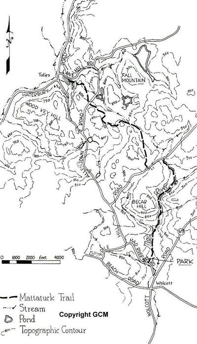
The power-line cut provides an entirely different habitat for 'weed' species. that do well in disturbed sites. Grasses and goldenrod have helped stabilize the open ground. Look for the blue blazes that lead back into the woods just above an old mill dam with stone foundations at the edge of Mad River.

The Mattatuck Trail follows Mad River downstream past the cascades and pools. One small footbridge crosses Break Hill Brook, which tumbles over rocks in a lovely hemlock ravine. The final hundred yards of trail leaves the hemlocks and enters mixed hardwoods where red cedar and yellow birch are very much in evidence.

Both the nortern and southern ends of this hike lie in the depths of a hemlock gorge within sight and earshot of clear running water. Either location will provide a perfect picnic site, but please carry out what you carry in. There are trash receptacles at Peterson Memorial Park.


Buttermilk Falls Preserve was aquired using the Conservancy's revolving fund. Area residents subsequently raised funds to reimburse the Conservancy.


CREDITS: Excerpts : The Nature Conservancy. Accuracy approx. 1989.


back