


To drop an extra car at the northern end of this section of trail, return to Kent and drive north on rt.7 to Cornwall Bridge. (7.5 miles) Once across the high concrete bridge in Sharon,take an immediate right down under the bridge. Head south along the Housatonic River for 1.4 miles. Park at the jct. of River Road, Dawn Hill Road, and Guinea Road.
Ownership of the 'ledges' has been traced back to the beginning of the 18th century when the SCHAGHTICOKE INDIANS held the land on the west side of the Housatonic River. Subsequently, Kent was organized (1783), and the northern section of the Indian Territory was sold to John Fuller. 50 year later, Fuller sold this land to Timothy St.Johns, whose name remains with the ledges.
The land records are not clear from 1833 until 1910 ( interesting!! ), when the Stanley Works of New Britain began purchasing large tracts of land on either side of the Housatonic in preparation for damming the river.( purchased from who ??!! ) The dam has yet to be built.
In 1976,the company gave 132 acres, including the St.John Ledges, to the Nature Conservancy and also granted an easement over part of the Appalachian Trail that runs north into Sharon, following the western bank of the river. In 1985, the Conservancy sold this tract to the U.S.National Park Service, while the Stanley Works conveyed additional sections of the Appalachian Trail Corridor to the NPS, which now owns and maintains the trail. Of the two thousand miles of trail stretching from Georgia to Maine, this stretch along the Housatonic River is considered by many to be the jewel in the crown.
The switchback brings the trail across an area that the soil scientists call rock land. Large boulders are jammed together, and the sparse soils caught between them appear to have been inadequate to support the forest vegetation. Probably drought and gypsy-moth caterpillars combined to kill the trees. A quick glance shows that there are as many dead trees toppled over as there are live ones still standing. In contrast,the herbaceous layer is well developed, with interrupted ferns on the left of the trail--'interrupted' because the fertile leaflets occur halfway along the arching, leafy frond--and delicate maidenhair ferns on the right.
The trail continues directly under the sheer cliffs that rise 60 to 80 feet above. These cliffs mark the eastern boundary of the Housatonic Highlands. Massi??, one of the oldest bedrock formations in New England, with gneiss dating from the Precambrian Period over one billion years ago. From across the river, these ledges that rise 500 to 600 feet above the Housatonic River are clearly distinguishable, along with mountain summits that rise yet another 300 feet.
Downhill from the trail, the forest is noticeably void of undergrowth due to an early spring fire several years ago. The fire swept along the base of the ledges, destroying many of the younger maple and ash tree that now can be seen sprouting anew. The oaks,with their bark, withstood the heat and continue to flourish. Increasing numbers of raspberry and blackberry bushes also grow in the wake of the fire.
Fire continues to be a problem along the western bank of the Housatonic because of the many camping areas developed at the rivers edge. The valley acts as a kind of funnel for wind currents that can fan even campfires out of control.
[ I dispute these comments somewhat-Early Spring Fire? I'd bet its hard to find one camper in this area 'early spring'. It can be below 32 degrees F till end of May.
NW Connecticut can have its DRY spells but it has no comparison to areas like the California mountains where a campfire presumed out can smolder in the ground for days or ? and re-start. In NW Connecticut the base of your campfire has nothing to smolder or burn such as feet of conifer needles,etc. So wind ? I'd say a fool starts a forest fire from a campfire and probably most fires are set by 'nuts'.
My uneducated opinion. In recent times some have become wise enough to realize many fires are intentionaly set-arson---and even some firefighters have been arrested for setting fires for 'work to do'....(no..I don't think this area but !!! --hey..not knocking firefighters !! They risk their life for you)
I just sometimes enjoy the excuses used to bring people under government control]-[website editor] [[ ps..2002-- There seem to have been a number of fires in NW Connecticut of recent but as to cause I don't know if a blame has been found.
Some have been blamed on smokers but later found to be lightning. Some unknown I guess.---- but don't think any have been traced to 'illegal campers'. hey--fires are dangerous and destroy but shut down the world because such might happen?
Look at it this way...ok...no campfires? no...the direction would be 'no campers']]
Yes...all up and down the Housatonic River area there was free non-government camping up till about the 1960's. Where have the fires been?
All over the USA people can 'wilderness camp' and campfires are used as a 100% reality and fires? One of first things that were done in Connecticut in particular some years back was to make all fires illegal unless in a government restricted zone under government constant observation.
Please a history of forest fires in this area from a simple properly built campfire?
With the state parks in NW Connecticut go back to their birth and observe their camping areas. Any evidence of any fire that scourched anything in last 100 years ? All these years of alcohol consuming campers !!! The occasional fire seems to be in some remote area and blamed on an 'illegal' camper'. I think most campers know how to properly treat fire..with caution !! [website editor]
The cliffs are almost bare. A variety of lichens encrust the steep pitches and turn the gray gneiss slightly green or brown. Black birches take root in crevices where soil accumulates and moisture is trapped. Chestnut oaks and an occasional mountain laurel grow in slightly deeper pockets of soils and, where the trail climbs through a moister break in the rock, basswood, a species typically associated with stream banks, can be observed. Here too,is the lovely, purple flowering raspberry, with its thornless,sticky-hairy reddish stem. Its showy flowers are in bloom during June.
The last leg of trail is an extraordinary climb up a long stone staircase that rises through one of the few breaks in the cliff face. At the top of the ledge, the trail leads south through vegetation dwarfed by the harsh climate on this exposed site. From the top of the ledges, the view of the Housatonic River Valley is superb. The river flows along the western edge of the narrow valley. The east bank is a series of terraces; the lower ones are used to grow crops or to grazy dairy cattle. The houses of North Kent cluster below, and even the tiny CEMETERY stones are quite distinct from this vantage point. Those fields abandoned by farmers in the past 20-50 years are full of red cedar. (web author-a red cedar?)
By the end of the 19th century, most of the forests in the Housatonic River Valley had been cut for charcoal to fire the large stone furnaces where iron was smelted. The upper slopes of the hillside opposite the lookout were amongst those logged to support the iron industry. The smelting furnaces can be visited to the north of Kent on Rt.7
If you were to continue southwest along the Appalachian Trail, you would enter Pond Mountain Natural Area and climb Calebs Peak. Instead, retrace your steps down St.Johns Ledges to the car. If you plan to continue on the longer hike north to Sharon, turn left and follow River Road (and the white blazes of the Appalachian Trail) upstream along the Housatonic.
The stretch of road running a half mile in each direction from the trail junction is noted by Noble Proctor to be one of the 'hot spots' in Connecticut birding. River Road in Kent is highlighted in his book 25 'birding areas in Connecticut' as being especially exciting during spring migration. Look for ospreys, red-tailed hawks, and turkey vultures overhead, mallards, black ducks, and wood ducks on the river and in backwaters. During migration periods, common goldeneyes and american mergansers may be seen. In may, the east-facing slope is alive with warblers.
The road continues north another mile to the old North Kent Bridge abutment. It passes several cellar holes dating from colonial times on the west side of the river, as well as a few modern camping sites along the river bank. The old sugar maples that line the road were planted a hundred and fifty to 200 years ago, and may last another 100 years
If you have driven this far, park here where its easy to turn around, and walk the rest of the way.
The scenic Appalachian Trail leads the hiker through a variety of forest types that line the Housatonic River. Hemlocks grow along the rivers tributaries, and mixed hardwoods and occasional grassy openings occur along the route, as do a few conifer plantations. The Housatonic River, though, is the major attraction. It rises near Pittsfield,Ma., and flows south past Great Barrington and into Connecticut. From Kent, its most western point, the river swings southeast through New Milford to Derby and empties into the Long Island Sound at Stratford and Milford--past the Conservancy's Milford Point. It's a 132 mile trip through a mosiac of forests and agriculture land dotted with towns and villages.
Here in Kent, the quality of the Housatonic River water was once rated 'B'---suitable for swimming,boating,and fishing. In 1976, however, the river was downgraded to class 'D' because of high levels of polychlorinated biphenols(PCB's) in its fish. Efforts continue to return the waters to their original class "B" rating and to designate a 41 mile segment of the Housatonic (from the Massachusetts-Connecticut border to New Milford) as a National Wild and Scenic River.
At the northern end of the road, the trail follows the river, passing an opening to cultivated fields. Continue to follow the white blazes of the Appalachian Trail. The trail joins a farm road to the north of an old foundation and continues past a spring that has been piped out to the edge of the road. The parking spot for a second car is a few hundred feet farther on.
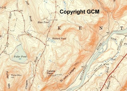
| I am getting confused myself. The Appalachian Trail went through Macedonia Brook State Park (from the south) and eventually ended up at the St.John Ledges area. The trail changed when the Federal Government bought a permanent 'right-of-way' for the trail. I think the above map is still correct as to St.John Ledges. The trail still does go through this area on it's old route. The confusion begins as to WHO owns the surrounding land as of 2008. The Nature Conservancy ? The Federal Government ? The State of Connecticut ? It appears the State of Connecticut owns a 'chunk' of land' along the Appalachian Trail as the trail goes north along the Housatonic River to Cornwall Bridge. This is the SAME route it has been on for decades. EXCEPT-the trail back in original days crossed the Housatonic River at Flanders Bridge (Flanders..a dead town/place name) and went through Kent Falls State Park and headed eastward. This area was a unique area and people did camp,etc. 'free' all along this area at one time. No crowds but a few people...enough not to feel too lonely. I remember as a little kid camping with my parents here. Till this day there is no development in the area and snooping the maps above one might study the changes over the years. Some older roads no longer exist but as very overgrown 'wood roads'. That whole area from the river inland up the mountains there is still NOTHING as of 2008. There used to be a few remote 'camps' I assume not strictly legal. (homesteading?) A couple houses still existed along River Road. If your lucky you might still find an old beer can in the woods. Fitzgeralds? Black Label from Boston? Above I quoted some 'excerpts' from some material dealing with the area around St. John Ledges. If you study the maps above you can see St. John Ledges and this is just an area the Appalachian Trail travels through a 'very steep' climb and one to be cautious with. |
