
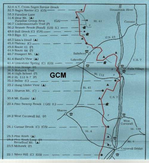
0.0 Drop off at the Housatonic Regional High School
0.1 Cross Housatonic River on U.S. 7. In 300 feet, turn left at a parking area and enter woods following old roadbed. Reach Housatonic River. Go right on berm between River and corn field for 500 feet; continue to right, around cornfield.
0.3 Cross U.S. 7 again, and enter woods, crossing several stiles.
0.7 Belter's campsite. Spring near Trail.
3.6 Sharon Mountain campsite-- This is your scheduled destination.
Points of Information:
1) There is a stream .1 of a mile further south along trail.
2) Best evacuation is 3.3 miles back north to U.S. 7.
Day 2-- 6.0 miles to Caesar Brook
0.1 Cross brook.
1.5 Cross state forest service road.
2.7 Side Trail to Pine Swamp Brook Shelter. Water Supply Nearby.
3.4 Trail descends through two huge boulders on path known as Roger's Ramp.
3.6 Cross hard-surfaced West Cornwall Road.
3.7 Cross Carse Brook on log.
4.6 Cross abandoned Surdam Road.
6.0 Cross abandoned Caesar Road. Camping area-- called Caesar Road Campsite on the AT map-- on knoll just south of brook.
Points of Information
1) Water should be available in the stream.
2) Evacuation Route. Go south along trail 1.2 miles to Knob Loop. Trail has blue blazes and leads off from left to U.S. 7.
3) Alternate evacuation route is to go 2.5 miles south along trail to Old Sharon Road. Blue-Blazed side trail (old AT) leads .5 miles to trailhead and parking area on U.S. 7. Total distance: 3 miles.
Day 3-- 3.8 miles to Silver Hill Shelter
1.0 A.T. and Pine Knob Loop converge. Short climb to view. Pine Knob loop has blue blazes.
1.1 Pine Knob lookout over Housatonic Valley.
1.2 Pine Knob Loop Trail leads left to U.S 7 and Housatonic Meadows State Campground.
1.3 Cross Hatch Brook
2.5 Cross old Sharon Road. Blue-Blazed side trail (old AT) leads .5 miles to trailhead and parking area.
2.6 Descend to Guinea Brook. In times of high water, crossing stream can be avoided by following dirt road left to Conn. 4. Turn right on Conn. 4 to rejoin trail.
2.7 Cross Conn.4 and enter woods.
2.8 Turn right, and climb very steeply to height of land.
3.8 Reach side trail to Silver Hill Shelter.
Points of Information:
1) Water is available 1.2 miles North to Guinea Brook or .9 miles south to dirt River Road. Go to road and turn left (north) and you will see a piped spring.
2) Evacuation route is to Conn. 4.
Day 4-- 1.1 miles to Conn 4.
0.0 Go back to the AT and head north. 1.1 reach Conn 4--pick-up at Cornwall Bridge
