
Follow white blazes of AT unless otherwise noted. New AT rules: all camping must be in designated sites.
Day 1 (4.9 miles): Disembark at intersection of Jug End/ Curtiss Rd and Rt. 41.
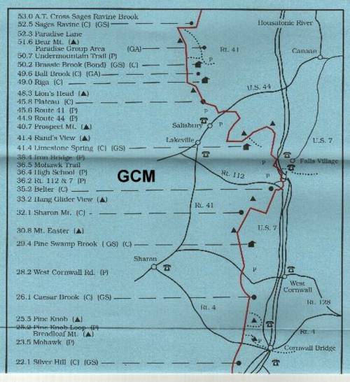
1.5 Walk down Jug End Road to trailhead, which is located 0.1 miles north of a piped spring. Water is untreated, but fill up here if you need to. You should start with full water bottles. At trailhead turn left sharply into woods and begin ascent.
1.8 Begin steep ascent. (Extra caution should be observed in wet conditions).
2.2 Reach crest of exposed rock faces. Trail turns north for brief distance and then resumes its southerly direction. Extensive views to the northwest and southeast; Mt. Greylock is clearly visible to the north.
2.6 Reach Jug End summit, with spectacular views.
3.0 Cross Intermediate peak.
3.4 Cross another intermediate peak.
3.8 Reach crest of Mt. Bushnell(1,834 ft).
4.3 In sag between Mt. Bushnell and Mt. Undine, turn right. (Blue-blazed Elbow Trail intersecting from left leads southeast to Berkshire School and Mass 41, about 1.5 mile).
4.4 begin ascending eastern slope of Mt. Undine.
4.6 End ascent along eastern slope of Mt. Undine.
4.9 Side trail to Glen Brook Shelter. Camp here.
Points of Interest: 1) Water available at spring (Jug End Road), later at stream which flows through saddle between Mt. Undine and Mt. Bushnell(crosses trail at 4.3 miles). Also water available at Guilder Pond, 0.3 miles south on trail from Glen Brook Shelter. Picnic Area here.
2) Evacuation Route: backtrack north on trail, follow Jug End Road to Rt. 41. Alternate Evacuation Route: follow Elbow Trail east(blue-blazed) to Berkshire School.
Day 2 (4.7 miles): Continue south on Appalachian Trail.
0.1 Cross Glen Brook and turn righ uphill 40 yards beyond.
0.4 Trail from Guilder Pond(2,042 ft) enters on right.
0.5 Enter Guilder Pond Picnic Area in Mt. Everett Reservation. Guilder Pond, second highest pond in Massachusetts, may be seen on right. turn left and ascend through woods up northeastern slope of Mt. Everett.
0.6 Cross road, bear left for 100 feet and turn right to Trail; continue ascent.
0.9 Leave woods and enter abandoned service road to firetower on top of Mt. Everett. Stone shelter at end of automobile road is 100 yards to left and below Trail(camping not allowed in shelter). Follow service road for 50 yards then leave service road for narrower trail.
1.2 Reach summit of Mt. Everett (2,602 ft). Steel firetower on top of Mt. Everett. Tower is no longer in service and is closed to public. Keep crazy footies on leashes here. Magnificent views from this łDome of Tactonics.˛ Trail bears left and begins descent on south slope of Mt. Everett. Trail is rough and steep, so be cautious, especially when trail is wet.
1.9 Reach sag where Race Brook Trail enters from left. Trail bears right and proceeds south, ascending moderate slope of Race Mountain. Blue-blazed Race Brook Trail leads east about 0.4 miles to designated campsite with outhouse and tent platforms, then to Race Brook falls. Five falls (one is 100 feet high) cascade down the mountainside. Mass. 41 is about two miles beyond. The falls are pretty groovy.
3.0 Reach summit of Race Mountain (2,365 ft).
3.2 Trail passes large cairn and begins to follow close to edge of escarpment. Outstanding views to northeast and southeast.
3.6 Reach Southern end of open cliffs and enter woods. Open area descends, gradually entering hemlock grove. Find Socrates dead here.
4.7 Enter wide woods road and cross Bear Rock Stream within a few yards. Open area on left leads short distance to falls and camping area with outhouse and fireplaces. Camp here.
Points of Interest: Groovy Falls. Water available at Guilder Pond(0.3 miles), Race Brook Falls(1.9 miles), and Bear Rock Falls(4.7 miles).
Evacuation Route: Mt. Washington Road from Guilder Pond Picnic Area leads to South Egremont. Road should be in use by cars, so this is a possibile option at start of hike close to Glen Brook shelter.
Alternate Evacuation: Dirt road down Mt. Everett descends east ultimately to Mass Rt. 41.Trail parallels Race Brook stream-follow to support crew base camp.
Day 3 (a few miles): continue on trail from campsite, following old woods road. Trail descends gradually here.
0.2 Spring to right of Trail.
1.0 keep to the left of the fork where obscure woods road leads off to right. Begin short, moderate descent into Sages Ravine.
1.4 Cross Sages Ravine Brook and proceed west up Sages Ravine beside brook. Youąll see large trees and waterfalls, interspersed by quiet pools. Another groovy spot. Specified sites are marked on the north side of the brook (to your right).
2.1 Paradise Lane Trail enters from the left. Paradise Lane Trail meets the Undermountain Trail 1.1 miles west of Conn. 41.
2.3 Turn right and start steep ascent of Bear Mountain (2,316 ft), the highest mountain entirely within Connecticut, with a view of the Housatonic Valley thatąs Hew-Sah-Tawn-Hic for you fo-net-hic pholks) to the east and south and the Berkshires to the north. Monument on left, erected in 1885, marks what was then thought to be the highest point in Connecticut. Boy were they wrong.
2.4 The Trail crosses the summit and descends to the south across a rock garden with stony ledges and scrub oak.
3.0 Bear Mountain Road, an old charcoal road, enters from the right. It led to the blast furnace on Forge Pond. Do not cook cous cous here. To the right one mile is Mt. Washington Road. Appalachian Trail turns slightly left and follows charcoal road.
3.2 Cross south branch of Brassie Brook with two log bridges. Camping area and Bond Shelter are on left.
3.8 Cross another brook with a bridge. Reach Ball Brook campsite. Camp here. There is a campsite just before bridge if Ball Brook is occupied. Do not camp at the leanto at Bond or Riga. The AMC does not allow group camping at Bond or Riga Shelter.
Points of Interest: Sages Ravine is awfully purty.
Water available at Sages Ravine and also at spring at start of hike near Bear Rock Falls. There are streams that parallel trail on the south side of Bear Mountain, about 0.1 miles and 0.25 miles to the east of the trail (on your left). These streams are runoff channels for the mountain which merge to form one fork of Brassie Brook. Another fork of Brassie Brook actually crosses the trail 0.1 miles north of the Bond Shelter. Brook at bridge just before Ball Brook Campsite.
Evacuation Route: Emergency trail towards the east is just north of Sages Ravine.
Alternate Evacuation Route: Undermountain Trail leads east to Rt. 41.
Day 4 (2.1 miles): Backtrack to Undermountain Trail and follow it east until you reach Rt. 41. Allow sufficient time for hike. Bus will pick you up at 8:15 A.M.
