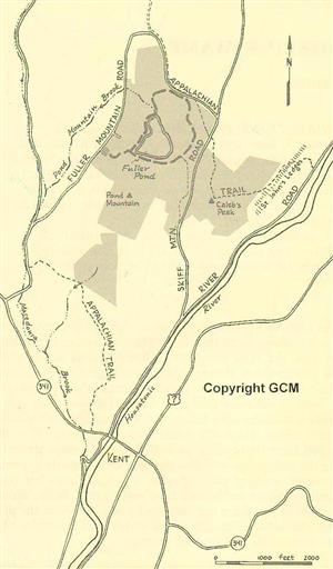
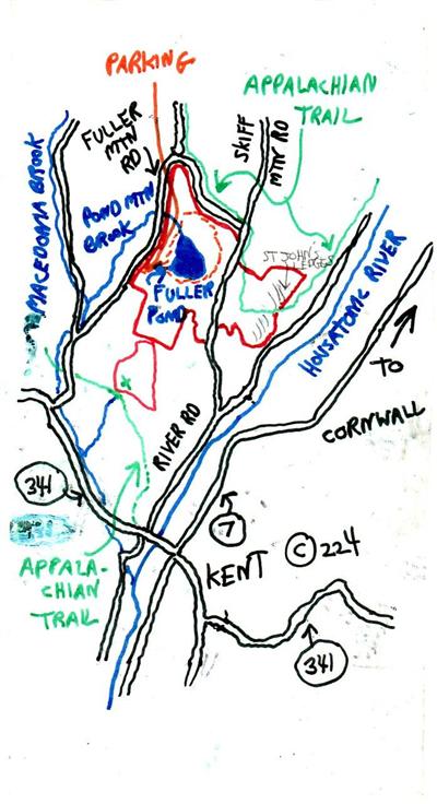


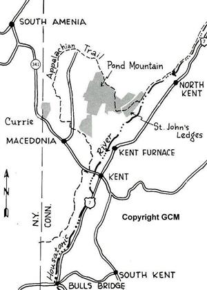
The Natural Area provides the hiker with a diverse landscape. Calebs Peak affords splendid views of the Housatonic River Valley. Pond Mountain reaches an elevation of 1,332 feet and gives a westerly view all the way to the Catskill Mountains in New York State. Fuller Pond, a spring fed lake, is an especially interesting feature of Pond Mountain. Created some 12,000 years ago as the Wisconsin Ice Cap retreated, it is exceptionlly deep and clear, and has been the subject of many research projects. The broad path that rings the lake is a pretty walk in any season.

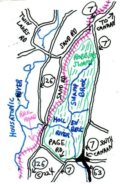
Robbins Swamp is the largest wetland in Connecticut, comprising more than 1,500 acres in Canaan. Of this, the state owns about 500 acres, while the conservancy, through the generous gift of Mrs.Louise Stanton, protects over a hundred acres in three tracts.
Sand Road runs along the base of a lime-rock ridge. Once the leaves have fallen, you can readily see the limestone mines where the white rock is exposed. It is the runoff from these cliffs, as well as the limestone underlying the valley, that enriches the soils and supports a special and rare array of plant species, which includes the bur oak, northern white cedar, and false melic grass. While access is difficult and there are only deer paths to follow, the preserve is included as one of the states best examples of a calcareous fen and seepage swamp.

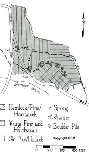
The preserves terrain varies widely. A very steep slope with thin soils is dominated by hemlocks and rises to a plateau of postagricultural land characterized by ashes, birches, and sugar maples. The eastern and northern sections, through which the Appalachian Trail passes, have been logged more recently, and hemlock is interspersed here with mixed hardwoods. Steep ledges cut east-west through the center of Hamlet Hill, and there are several red-maple swamps in the preserve.
Donors of the land for the preserve include Gustavus Pope, Agnes Forsyth, Mary McClintock, Henry Mitchell, John F.B.Mitchell, and Dorothy R.Walker.
In the 19th century, the entire area was cut over for charcoal to fire iron furnaces. At lower elevations, numerous charcoal pits can still be detected. American Chestnut was also salvaged from these hills during the 2nd decade of the century.
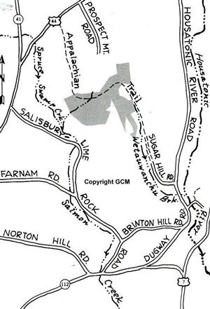
An old logging road leaves Rt.341 and cuts diagonally across the steep slope in the southern section of the preserve. The northeastern boundaries of the preserve are shared with Macedonia Brook State Park, through which the Appalachian Trail passes.
Dr.Bethia S.Currie donated the land for this preserve.


Directions:From the junction of RT's 4 and 125, go south into the village of Cornwall. The road ends at Marvelwood School and faces Coltsfoot Valley. Go left on Valley Road, which very soon bears sharply right at the 'Corner of the Pines'. Take the next left onto Essex Hill Road and continue for 0.2 miles. Park on the left at the preserve entrance sign near the large boulder topped by a white pine.
The Calhouns have long been the guardians of the tract, having bought the property in 1883 to prevent it being logged. The stand is a mixture of mature white pines and hemlocks and some northern hardwoods.
Follow the trail leading from the parking area up behind the large boulder. It leads through a tangle of elderberry and wild roses, past an uprooted white pine, and connects immediately with the Mohawk Trail. Follow the blue blazes in under the pines.
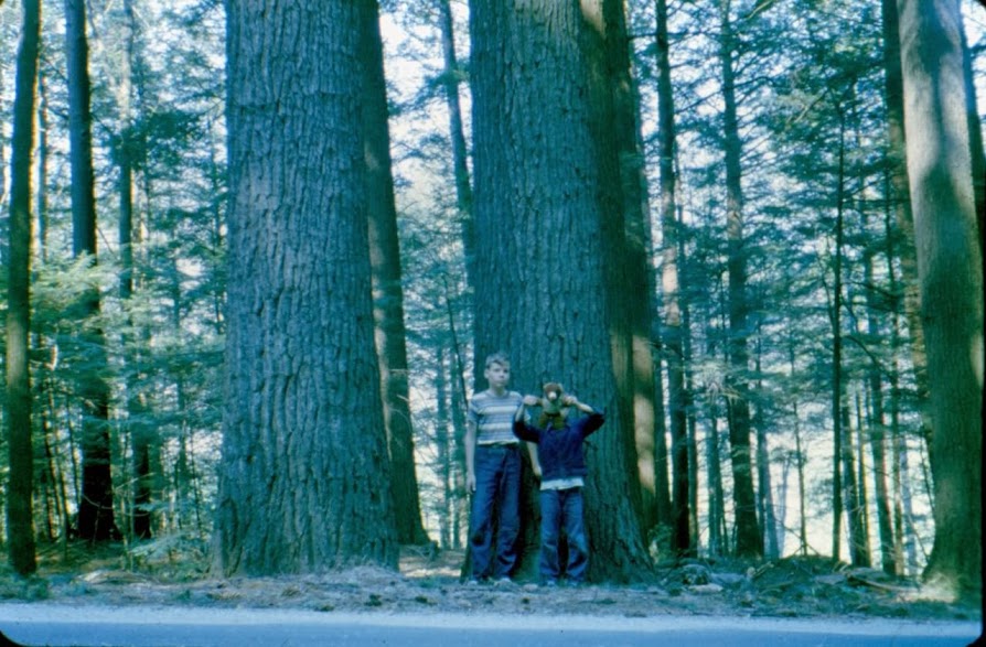
Cathedral Pines has been recognized as a National Natural Landmark by the National Park Service. The area is the most massive single stand of old-growth white pines and hemlocks identified in New England and the Adirondacks. In 1988, the Connecticut Botanical Society presented The Nature Conservancy with a certificate of commendation celebrating the largest white pine tree in Connecticut, which is growing in Cathedral Pines.
Many have pondered the origins of Cathedral Pines, but there is no proven theory. Piecing together certain facts continues to be an intriguing process.
Unless influenced by some natural disaster, such as flood, fire, wind,or insect infestation, the natural development of an even-aged pine stand often runs as follows: an old field is abandoned and seeds in with white pine. In this northern climate of Connecticut, the white pine, rather than a red cedar, is a natural invading species, since it requires full sunlight to germinate and develop. As they grow, the young pines, mixed with a few hardwoods, crowd the field. With ensuing years, their branches collide and must compete for light. Many of the smaller trees are crowded out by the larger and healthier trees. As the forest canopy forms overhead,the lower branches of the pines are shaded and eventually wither and die. Because the trees grow close together with plenty of light from above, they develop straight, tall trunks. However, in the dense shade thrown by the mature trees, there is a distinct absence of white pine regeneration.
Another plausible scenario in white pine development occurs when only a few white pines invade a fully lit pasture. They have all the space they need to grow, and their lower branches develop and thrive in the full sunlight. Their open-grown form is quite distinct from the slender, towering giants of Cathedral Pines, and they provide a seed source for another generation of more closely spaced white pines.
Neither development sequence applies to the white pine and hemlock stand at Cathedral Pines. The dominant white pines here had been considered an even aged stand, roughly 200 years old, until the trees blown down by a tornado in August 1980, damaged a portion of the forest and provided The Nature Conservancy with an opportunity to take a much closer look at the stand. Each downed tree was methodically cored and accurately dated by counting the annual growth rings. Unexpectedly, several 300 year old pines were discovered. Equally surprising, their diameters and straight growth form were similar to those of the trees a full 100 years younger that grew right next to them.
These discoveries posed new questions about the origins of the present stand. Had these older trees been part of an extensive white-pine stand which was lost to some naturally occurring disaster in 1780 ? Or had the 2 generations of pines been part of a northern hardwood forest whose hardwood component had been devastated by an insect infestation ? It seems most unusual that so few 300 year old white pines remain, and that the ones in the Conservancy found were so straight and slender.
Well to the north of the trail is the site of a specialized logging operation. A contractor was looking for a stand of long, slender white pines over a hundred feet in height, no greater than eighteen inches in diameter at the butt, and no less than nine inches at the tip. The white pines located just to the north of what was to become the Conservancy's boundary were found to be ideal for his purposes,and the cutting began in 1953.
The contractor brought with him a team of Oneida Indians from upper New York State to do the cutting. The trees were felled one on top of the other so that the tip of the most recently dropped tree would cushion the fall of the next tree brought down. In so gentle a fashion, a tiny saw-whet owl was brought to the earth unharmed.
The logs were piled onto a flat-bed trailer truck and driven to New York. The stems were so long and flexible that roughly two feet in length were lost as the tips dragged and were shorn away during the drive. The logs were ultimately used as pilings to support the Tappan Zee Bridge accross the Hudson River as well as Israel's Tel Aviv airport.
