
The two-mile loop trail leads the observant hiker through a variety of habitats, and the human influence on the landscape is evident. Iron Mountain has a history typical of much of Litchfield County. Early clearing for grazing, cultivation, and timber cutting in the 1700s was followed by a gradual abandonment of the land starting in the early 1800s. Besides the stone walls and forest road, scattered segments of barbed wire fence give evidence of former fields in the upland forest. After much of the area was reforested, the charcoal industry again cleared nearly all of the drier forest in the mid-to late-1800's. After the charcoaling ended, the cleared areas were again left to reforest. The upland oak woods today are 60 to 100 years old, and remnants of charcoal pits are still visible.
Recent work on the trail by Conservancy staff and volunteers has made the trail safe and enjoyable for hiking. If you need some respite from your everyday routine, this preserve is sure to be a good choice.
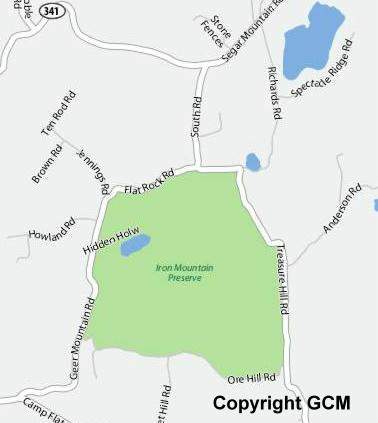
Directions: From the junction of Routes 7 and 341 in Kent, take Route 341 east for approximately three miles. Go left on South Road, left on Flat Rock Road, right on Treasure Hill Road, then look for the preserve entrance on your right.
Iron Mountain is among the sites included in the chapter's Preserve Sampler, a guide to Connecticut's preserved sites.
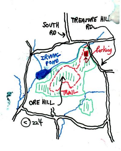
Follow the trail leading from the north of the parking area. It leads downhill to the west for some length, then turns south, following the slope contour, to an abandoned orchard.
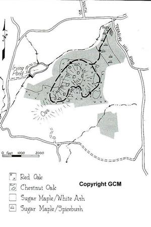
The west-facing slope is characteristic of much of the woodland at the 283-acre Iron Mountain Reservation. Typical of northern hardwood forests, the preserves well-drained uplands are dominated by large sugar maple, ash, red oak, and black birch trees. Prior to the early 1900's, the American chestnut was also a dominant species.The understory is largely filled with young hardwoods, maple-leaved viburnum, and witch hazel. The forest floor supports the grassy-looking Pennsylvania sedge and the sweet-smelling,hay-scented fern, as well as clubmosses and partridgeberry.
The many stone walls that pattern the woodland date from the early colonization and the clearing of the land. Because they are so steep, cleared areas probably were grazed, rather than cultivated.
The stream, which in summer can only be heard but can be seen once the leaves have fallen, flows over private property beyond the preserves northern boundary, which should be respected. This is one of two streams that feed Irving Pond below (also privately owned).
On the steepest incline of the trail there is a large ,thirty-inch-thick American chestnut swamp dating from approximately 1910, when the chestnut blight swept through the chestnuts natural range, killing the species. The wood was prized for its size, strength, and great beauty, and its loss caused a major impact on the forest industry. Much of the diseased wood was salvaged from the forests and stored for future use. Caches of chestnut lumber, milled in the early 1900's and hidden in barns, are still being discovered.
The lower slopes of the west-facing hill are quite moist, even in summer. In early spring, different types of violets carpet the slightly elevated terrain at the edge of the wetland. The two large trees that appear like sentinels at either side of the trail are shagbark hickories. The ground beneath them is strewn with the thick husks that cover the hickory nutshell. Nearby are a number of large hophornbeams, a tree that ordinarily reaches only three to four inches in diameter. More typical of poorly drained soils are yellow birches with spicebushes underneath.
Crossing an old woods road, characteristic of the many overgrown roads forming a network across Iron Mountain Reservation, the trail soon drops past two huge, open-grown sugar maples. Their broad-reaching branches are now bare, and the trees appear to be dying. They are probably well over 200 years old.
There is a long traverse across the base of the hill where the poorly drained soils remain soggy even in summer. It is a curious site on which to find an old apple orchard, but there it is, caught up in a tangle of grapevines. Intermixed with the fruit trees are spicebushs and an herb layer layer of sensitive ferns and skunk cabbage. The orchard extends onto the moderately well drained soils where large, double-stemmed black birches now grow between the rows of apple trees. The ground is covered by lush Pennsylvania sedge.
The trail exits the orchard through a stone wall, turns west (right), and meets the loop-trail junction. Turn north (right again) and pass back through the stone wall. Follow this trail, which becomes an old road, for approximately 0.3 mile, to a junction on the south (left) of the road.
The far western end of the orchard is slightly higher, with well-drained soils that support shagbark hickory. There are probably two dozen large hickories growing here to the exclusion of most other species. The trail soon picks up an old level road that runs around the shoulder of Iron Mountain. On the north-facing slope, the forest composition changes to include other hardwood species, such as large, white paper birches which lend a distinct northwoods flavor, and black cherry and beech trees. There are also numerous black birches and occasional hemlocks.
A large yellow birch on the left of the trail stands opposite an enormous boulder, or glacial erratic, measuring twenty by thirty feet accross and ten feet high. The erratic was dumped off by a retreating glacier as it melted some fifteen thousand years ago. Now it is draped in grapevines, and a few cherry saplings have taken root up top.
Its fairly easy to miss the trail to the south (left). If you come to a spring that issues from several boulders on the south and privately owned Irving Pond that lies just ahead, -you have gone too far. Retrace your path approximately 300 feet and take the trail, now on your right.
The hike uphill goes through a remarkable stand of striped maple, so named for its green-and-white-striped trunks. This species has enormous leaves (sometimes eight inches across), which some say resemble the webbed foot of a goose. In full summer, the greenish light that filters through these great flat leaves is especially pretty. Violets and Canada mayflowers cover the trail in early spring, and shadbushes blossom in the increased light at the trail edge. As spring progresses other plants flower, including starflowers, wild geraniums, and wild sarsaparillas.
This side of the mountain is peppered with charcoal pits left from the mounds of smoldering hardwood burned to produce charcoal. The level,circular areas, measuring twelve to fifteen feet across, still have small chunks of charcoal just below the surface of the ground, and the soil is charred a rich black. There is one pit directly in the trails path.
As the trail rises, the forest composition changes. The large hemlocks that occupy the midslopes are stunted at higher elevations, and at the summit they are totally bare of needles-victims of gypsy-moth caterpillars. The summit is dominated by multiple American chestnut sprouts intermixed with chestnut oaks. These, too, have been attacked by caterpillars. Only the huckleberry and low blueberry continue to thrive, along with an occasional mountain laurel.
The summit is also characterized by handsome outcrops of grey-to-pink gneiss, with darker black mica (biotite) present in quantities from flecks to streaks. There are also small amounts of magnetite-naturally magnetic lodestone, an important ore of iron-on the reservation. (if you have a compass with you it may behave erratically, thanks to an abandoned magnetite mine which lies outside the reservation.)
The descent from the summit is quite steep, and passes great slabs of bedrock with common polypody ferns growing on them. Here the hemlock has fared better and still retains its needles. Farther below,the trail runs through old fields that are now reverting to young woods. Blackberry and raspberry bushes are quite frequent,and in other places Pennsylvania sedge carpets the forest floor.
At the junction with the loop trail, go straight through the stone wall (bearing right) and follow the same trail by which you entered and continue across the abandoned apple orchard, through the forest,and out to your car.
