
Follow white blazes of AT unless otherwise noted. New AT rules: all camping must be in designated sites.
0.5 Race Brook Falls, a series of five cascading waterfalls that descend several hundred feet. The falls are a good lunch spot, but use caution under wet conditions here.
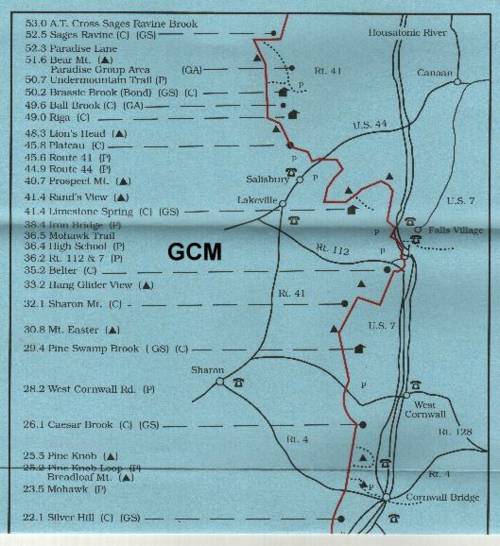
1.9 Find designated campsite. Camp at top marked site with platform. Camp here.
Points of Interest: Optional day hike up to the summit of Mt. Everett (2,602 ft). If you hike 0.4 mile past the site on the Race Brook Trail, you will come to the junction of this trail with the Appalachian Trail. If you hike 0.7 miles North on the AT, you will reach the summit. The ascent is rough and steep, so be careful when wet. There is an abandoned firetower at the top and a magnificent view of the surrounding Taconic mountains (Mt. Greylock, Monument Mountain) Water is available from Race Brook. Evacuation Route: Hike back down the Race Brook Trail to Rt. 41. Support Crew will be at base of trail.
Day 2 (4.6 miles): Hike west on Race Brook Trail towards the Appalachian Trail.
0.4 Find junction with AT. Go left here and hike south.
1.5 Reach summit of Race Mountain (2,365 ft).
3.2 Enter wide woods road and cross Bear Rock Stream. Open area on left leads short distance to falls and camping area with outhouse and fireplaces. Trail descends gradually, following old woods road.
3.4 Spring to right (west) of Trail.
4.2 Keep to the left of fork where obscure woods road leads off to right.
4.6 Cross Sages Ravine Brook. Trail proceeds west beside brook up through the Sages Ravine. there are lots of groovy waterfalls and still pools, with a host of large trees permeating the space. Specified campsites are marked on the north side of the brook. Camp here. No open fires anywhere cause you just passed into Connecticut. (We are not in Kansas anymore !!!! ...)
Points of Interest: Sages Ravine is really cool. This is one of the most popular sections of the AT, so be courteous and polite (there may also be a caretaker here). You'll find swimming here as well as great luncheon spots, if you haven't eaten already. Water available at start at Race Brook, later at Bear Brook, and finally from the Sages Ravine Brook. Drink up. (NO ALCOHOL !! THIS AREA IS A TRAP. GOT FINE MONEY OR YOUR TRIP BECOME A JAIL TRIP ??)
Evacuation Route: Hike back down the Race Brook Trail to Rt. 41. Support Crew is stationed here.
Alternate Evacuation Route: Hike further south on the AT (0.7 miles) until you meet the Paradise Lane Trail on left. Follow Paradise Lane south until junction with Undermountain Trail. Go left here and follow Undermountain Trail east to Rt. 41. Total distance from Sages Ravine campsite is 3.1 miles.
Day 3 (6.6 miles): Continue south on Appalachian Trail.
0.7 Paradise Lane Trail enters on left.
0.9 Turn right and start steep ascent of Bear Mountain on steep vertical rock steps and slabs. Use caution in wet conditions.
1.2 Summit of Bear Mountain (2,316 ft). You'll find a monument on the left celebrating Bear Mountain as the highest point in CT. It was erected in 1885, before nobody knew nothin'. Bear Mountain is the highest mountain entirely within Connecticut's borders, but there are other higher points whose bases overlap the state territories. In case you're desperate, this is good info to impress footies.
1.3 The Trail crosses the summit and descends to the south across a rock garden with stony ledges and scrub oak.
1.9 Bear Mountain Road, an old charcoal road (lots of cookouts back then) enters from the right. It led to the blast furnace on Forge Pond. to the right one mile is Mt. Washington Road. AT takes a slight turn to the left and follows the charcoal road.
2.1 Undermountain Trail enters on left. This is known as Riga Junction.
2.5 Cross south branch of Brassie Brook with two log bridges. Camping area and Bond Shelter, built in 1980 by the AMC, are on the left.
3.1 Cross another brook with a bridge. This is Ball Brook. Camping area just before brook, without a shelter or outhouse.
3.6 Trail starts to descend gradually through mixed birch and hardwood forest. Yellow -blazed trail to right is a continuation of the old charcoal road to Forge Pond and crosses private property. Appalachian Trail goes straight.
3.8 Reach Riga camping area (no shelter or outhouse).
4.0 A double light-blue blaze on a tree indicates the start of the Bald Peak Trail to the west, which leads one mile to the Bald Peak (2,016 ft) and Mt. Washington Road.
4.4 Reach north outlook of Lions Head, with views to the north of Bear Mountain and Mt. Greylock in the distance (about 40 miles away). descend, go through small dip and pass blue-blazed Lions Head bypass trail to right. It descends and rejoins the AT in about 0.1 mile. Use the bypass trail in the event of rain. Ledges on Lions Head are steep and slick in bad weather.
4.5 Reach summit of Lions Head (1,738 ft) with some stellar views. At summit, Trail takes a sharp right down west side of mountain. Below summit of Lions Head, south end of blue-blazed bypass trail enters from north.
4.7 Trail turns sharply to left and blue-blazed trail continues ahead. (This is known as the Lions Head Trail, this is a former Appalacian Trail route, which leads 0.4 mile to Bunker Hill Road, where cars may be parked).
5.0 Cross first of two old charcoal roads
5.4 Cross small stream.
6.5 Cross motorcycle trail. AT is marked by a sign that continues on left.
6.6 Trail enters clearing, turning left. At this point, there is an outhouse, spring, and Plateau campsite. Camp here.
Points of Interest: Lions Head is awfully purty, but be careful if weather is poor. Water available at Brassie Brook and Ball Brook, both of which cross the AT, and also at the stream and spring near Plateau Campsite. Alternate branches of Brassie Brook also descend the south face of Bear Mountain, paralleling the AT. They are about 0.1 and 0.25 miles east of the Trail, respectively. It is probably wise to top off at Ball Brook, since water is not always available further on.
Evacuation Route: Follow AT south past Plateau Campsite 0.2 miles to Conn 41.
Alternate Evacuation Route: Follow either Paradise Lane or Undermountain Trail (Paradise Lane leads into Undermountain Trail) east to Conn 41.
Day 4 (0.2 miles): Continue south on AT. You could probably long jump to the pickup. hike 0.2 miles to Rt. 41 for pickup at 8:15 A.M.
