
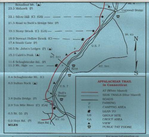
0.0 Head south on AT. 1.1 reach Silver Hill Shelter.
2.0 Reach the intersection with dirt River Road, which parallels the Housatonic. A few feet to your left (north) is a piped spring. (To get to Cornwall Bridge, follow road beyond spring to Swift's Bridge. The road straight ahead leads to 1.5 miles to Cornwall Bridge.) Go right at the intersection. The trail leaves the road, goes down an embankment, and stays close to the river. The trail follows an abandoned section of road below hayfields on right.
4.2 Cross Stony Brook. Water is reliable here. Campsite is in this area.
1.1 Pass through red-pine plantation. Continue on road close to river.
3.8 Reach Caleb's peak. Bear left and descend slightly through forest.
4.4 Cross Skiff mountain Road.
4.6 Cross Choggam Brook-- usually dry in late summer.
6.7 Trail straight ahead is old A.T.
7.2 Cross Macedonia Brook on log bridge and cross pasture.
7.3 Reach Conn. 341. Trail crosses road and enters woods on other side.
7.6 Side trail leads 200 feet to water and Mt. Algo Lean-to.
Campsite 0.9 Cross Thayer Brook; ascend steeply on rocky path.
2.8 Descend into Rattlesnake Den, a ravine with large hemlocks and jumbled boulders. Cross Brook and ascend gradually. Reliable Water, and campsite, and a privy on a side trail.
2.8 Descend into Dry Gulch, another rocky ravine. Ascend steeply out of Dry Gulch and then climb steadily along eastern slope of Schaghticoke mountain.
3.1 Reach Indian Rocks and an outlook to the east.
3.2 Trail crosses assumed Connecticut border (a sign is painted on a rock), but the actual border is 700 feet to the west. The is the first of three crossings of the border.
3.4 Trail reaches height of land and starts a gradual descent.
4.5 Reach gravel road and turn left. Follow the road, which become hard-surfaced.
5.8 Reach Dogtail Corners. U.S. 7 is 1.5 miles to left (east). Trail turns left on road.
6.5 Pass granite state boundary marker on left and re-enter Connecticut.
7.0 Reach Parking area just before road crosses river. Trail goes south on old woods road.
7.4 Leave road and follow Trail along banks of Housatonic River.
7.9 Pass though a stone wall and under some power lines. Cross a small brook.
8.0 Cross Ten Mile River on Ned Andersone Memorial Bridge. Turn Right and follow bank of Ten Mile River. Campsite is in this area.
