MAP--Year Unknown-1960's ?? 1950's ??
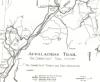
ST.JOHN LEDGES TO SCHAGHTICOKE RD.
[0.0]From junction with Schaghticoke Road go west on Conn.341.
[1.1]Trail follows road to Macedonia Brook Road where it turns right toward Macedonia Brook State Park.
[1.4]Road crosses Macedonia Brook.
[1.8]Cross the brook again over cement bridge.Just beyond bridge, take left fork into Macedonia Brook State Park. There is a good parking area just beyond the park entrance. [2.0] Turn left and proceed gently uphill through a mature hardwood forest leaving road behind at this point.
[2.4]Reach a leveling-off spot as trail proceeds along the east shoulder of the mountain. Continue to ascend.
[2.7]Reach summit and level off.
[2.8]Approach state park marker indicating no hunting allowed.
[3.0]Reach Chase Mountain Lean-To on stream. This is the first water since leaving Macedonia Brook Road.
[3.3]Cross brook. Trail continues down along east bank of brook. There are several campsites in this area. Beyond brook, 125 feet.Trail turns left. A yellow-blazed trail proceeds 0.6 miles down the stream to the right. This is Chase Mountain Trail which proceeds down to Macedonia Brook State Park. The trail continues to the left moderately ascending a ridge.
[3.5]Trail reaches outlook on South Cobble Mountain and starts to descend with fine views to the east.
[3.8]Trail starts to descend trough a forest.
[4.0]Trail reaches a large open camping area without water. Trail starts to gradually ascend again, through a little dip, then back up again. Most of this section continues to be level.
[4.1]Trail starts to descend more steeply and in 50 yards reaches another level section.
[4.2]Unmarked trail takes off to the right and leads down to Macedonia Brook State Park. A.T. continues ahead.
[4.3]After passing through a little dip, the trail starts to ascend gradually through a lovely mature hardwood forest. Just before summit, the blue-blazed Cobble Mountain Trail comes in from the right. This leads 0.8 miles to picnic area in the park.
[4.6]Reach the top of Cobble Mountain with splendid views to the west of the Catskills and to the north of the Berkshires, with the Taconics in between. Below is Chickadee Valey. There is a lovely grass campsite at the top of the mountain but there is no water. There is an excellent second site on top of the mountain, and a third campsite on the ridge several hundred yards from each other. These are all part of CAMPING ZONE 13A.
[4.8]Trail heads sharply down the mountain to the northeast. Trail is very steep through this section with many large rocks. The descent is difficult especially in wet weather and should be negotiated with caution.. It may be avoided by descending the Cobble Mountain Trail and then going north through the park to pick up the A.T. again at '4 corners'
[5.0]Trail reaches a sag and crosses a small brook, and then proceeds back up over a ridge.
[5.1]Pine Hill Trail to the right goes down 0.5 miles to Macedonia Brook State Park. A.T. turns left and heads up through a gulch and then a moderate ascent. Trail soon becomes steep and rocky..
[5.4]Reach the top of Pine Hill and start down again.
[5.6]Trail joins gravel road and turns right.THIS IS THE HISTORIC CHIPPEWALLA ROAD which once ran from Dover to Kent.
[5.7]Cross grassy road and continue ahead on right fork. This road was built by the CCC and used to be the main road through the park, continuing on to Ellswoth and Sharon.
[5.9] Enter large campground known as '4 corners' and join Macedonia Brook Road. Turn right. Picnic tables, campsites, outhouses and a pump with drinking water are available. Two streams converge. After crossing Macedonia Brook, there is a water pump to the right. A camping permit obtained from the forest ranger cabin 2 miles down the road is required for the use of these sites.
(in season, all valley campsites are booked well in advance) [website editor:1999 and prohibition has brought this situation to close to 100% vacancy during the weeks and small occupancy weekends. Minus those hangovers a better utopia ??!!]
No permit is needed to camp in the mountains of this state park. The next camping area is on the River Road, past St.John Ledges, about 6.6 miles from here. Leave the dirt road at '4 corners' and proceed opposite the pump on a abandoned town road.[again part of old Chippewalla Road-website editor]
Trail leaves the campsite area uphill on the right side of the brook. Road becomes a rutted trail in ascent through a mature hardwood forest.
[6.5]Double marker indicates trail branches to the right leaving the road behind.
[6.7]Reach a plateau and then start descending.
[7.1] Join paved road. Turn sharp left. The hard surfaced road is Fuller Mountain Road and from here to the top of St.John Ledges is about 2 miles. This part of the trail borders on land trust property owned by Pond Mountain Trust. No camping or fires are permitted on this property.
[7.2] Fuller Mountain Road comes in on one leg of a 'Y' with the Appalachian Trail Road, so-called because, before it was paved, it was the Appalachian Trail route.
[7.9] Trail leaves the road and proceeds up through the woods to the right. Trail gradually ascends.
[8.2]Trail descends back to the road passing through a wildlife sanctuary (Pond Mountain Trust) for about 1 mile.
[8.5] Turn to the right.
[8.8] Reach the top of a rise and start to gradually descend.
[8.9] Reach the top of Calebs Peak (1,160 feet) with fine views off to the southeast of the Housatonic River winding below near the village of Kent. Trail zig-zags steeply down the first section of descent.
[9.1] Descend off ledges using well designed rock steps which make the descent fairly easy. The trail levels and continues to descend gradually.
[9.3] Trail starts to ascend through a mature forest.
[9.5] Reach a spectacular overlook of the Housatonic Valley. This is the top of St.John Ledges owned by the Nature Conservancy. Formerly the trail descended straight down the ledges which was (as is) a very difficult descent.
Now the trail turns immediately left at the top of the ledges following the open ridge for 100 yards, then descends a well-engineered staircase built by the AMC crew from New Hampshire. The descent is now feasable, though a bit of a knee bender.
The stairs help the route down a 500 foot drop through steep granite cliffs. (these cliffs are used for practice rapelling.) Turn immediately left under these cliffs and proceed gradually down a well-cut trail.
[10.1]Reach the road where there is ample parking, and turn left along the Housatonic River. This gravel road, known as River Road, follows the river from Kent to Cornwall Bridge.

From the Guide to the Appalachian Trail Trail in Massachusetts-Connecticut-by the Appalachian Trail Conference-P.O.Box 807-Harpers Ferry,W.Va.25425 [1983]
